
Walk a Brownsburg Street
A useful street directory result is built one address at a time. Start with the exact number and road name in the Hendricks County XSoft property portal. That row can supply the parcel identifier, assessed owner, property class, and map route. The parcel number is often more stable than a street label. Do not treat the tax mailing address as the physical location. It is where the owner receives notices.
- Search XSoft. Copy the property address, parcel number, owner label, and retrieval date exactly.
- Open the Town parcel map. Select the same parcel, inspect its lot, then pan along the road.
- Use the owner name in the Recorder index. Match the deed's legal description to the mapped land.
- For voting evidence, use the state name, birth-date, and county form or ask about a lawful file request.
- For an older household, consult dated maps, a proven directory volume, census material, obituaries, and house-history resources.
The chain is address to parcel, parcel to owner, owner to deed, and dated evidence to possible occupancy. A deed proves a transfer, not continuous residence. A voter result confirms registration, not every person at that address.
Brownsburg Street Search Fields
XSoft replaced the retired county parcel search. Its basic entry accepts an owner, address, or parcel number after at least three letters produce suggestions. The Data grid offers direct filters, while Advanced Search groups parcels by district, sale, value, and physical traits.
| Search area | Field | Street use |
|---|---|---|
| Home | Owner, address, or parcel | Find one current property row |
| Data | Owner, Address, Property Number | Filter the grid and open map or detail links |
| Advanced | Neighborhood and District Name | Separate town and township groupings |
| Advanced | Class, year, area, acreage | Limit results by recorded traits |
| Advanced | Sale Price and Sale Date | Locate a transfer range for deed research |
The complete State ID matters in legacy instructions; Hendricks identifiers begin with 32, and a partial number may fail. Near a boundary, try the street without a city label. Use current XSoft for live data and ask the Assessor for a missing property record card.
The XSoft Advanced Search source displays those optional controls.
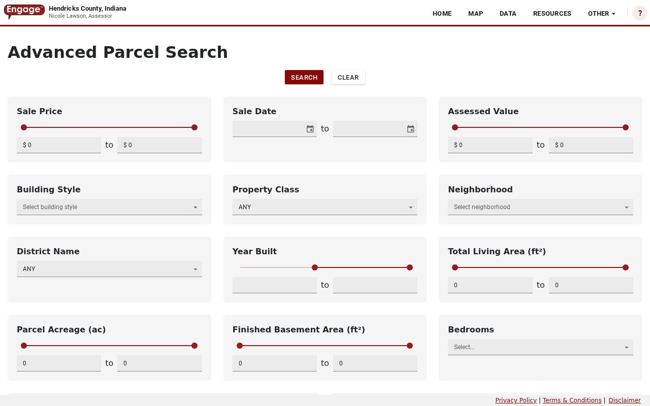
The capture confirms that these fields group property rows, not household members.
Brownsburg Address Data Grid
The Data view compares a bounded run of parcel rows. Visible columns include Property ID, Owner Name, Address, City, Map, Detail, and Services. Page controls offer 25, 50, or 75 rows. Keep the query to a road segment instead of publishing a broad owner list. The portal said the current property record card display was unavailable during research, so the Assessor remains the fallback.
The public XSoft data grid shows its address and property-number filters.
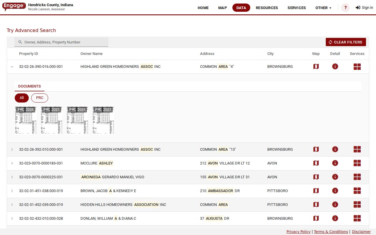
This view compares parcels, but an assessed owner is not a complete list of occupants.
Map Brownsburg Streets by Parcel
The Town Official Parcel Info Map has separate searches for owner name, parcel number, property address, and subdivision. Each offers up to six suggestions. Select the address, open its parcel, and pan along the road. The table can filter to the map extent and export rows. Clear or widen that extent before deciding the street has ended.
Parcel_Info includes legal description, acres, subdivision, lot, township, council district, zoning, flood, annexation, utilities, and TIF fields. Corporate Limits and Road Centerlines are separate layers. No dedicated radius tool or ZIP search was found.
- Parcel
- A land unit and identifier joining assessment and map records.
- Situs address
- The physical site, distinct from a tax-mailing destination.
- Plat
- A recorded map establishing lots, roads, easements, and subdivision geometry.
- Criss-cross directory
- A dated volume arranged by address or telephone number, not just surname.
Brownsburg Records Keyed by Address
No official roll answers who lives on every Brownsburg street. Each set proves a narrow fact, and several lack street-browse controls. The access routes distinguish online sources from counter, mail, archive, and defined public-record requests.
| Record | Keeper | Street evidence | Access route |
|---|---|---|---|
| Property data | County Assessor | Parcel, owner, address, class and map links | XSoft; office for missing PRC |
| Parcel GIS | Town of Brownsburg | Adjacent land, legal, lot, zoning and boundaries | Public ArcGIS map |
| Deeds and plats | County Recorder | Parties, dates, book/page and legal description | Doxpop, Recorder, archive, microfilm |
| Voter record | IndianaVoters, county office | Individual registration and voting geography | Name, birth date, county; lawful request |
| Planning record | Town Development Services | Project, plat, annexation or parcel context | Office, agendas, portal, APRA |
| Historic clue | Libraries and archives | Dated map, census, obituary or directory evidence | Catalog, Indiana Room, staff help |
USPS validates a postal label only. MyCase searches parties, not roads. The permit portal was inaccessible during inspection, so request a record by exact address, parcel, type, and date span. Agencies need not create a street roster they do not maintain.
Follow Brownsburg Street Deeds
Once XSoft identifies an owner, search that name as grantee in Doxpop and confirm the legal description. Read the deed's grantor and search that seller as grantee for the prior transfer. Account for spelling, spouses, estates, trusts, and businesses. Save the document number, instrument, recording date, book/page, and image status.
Provider-reported online coverage starts in January 1977. Earlier books require the Recorder, County Archive, State Library microfilm, or FamilySearch. Deed volumes reach into the 1820s, and transfer cards add historical tax clues.
The Doxpop Recorder interface shows party-name, document-number, and book/page routes.
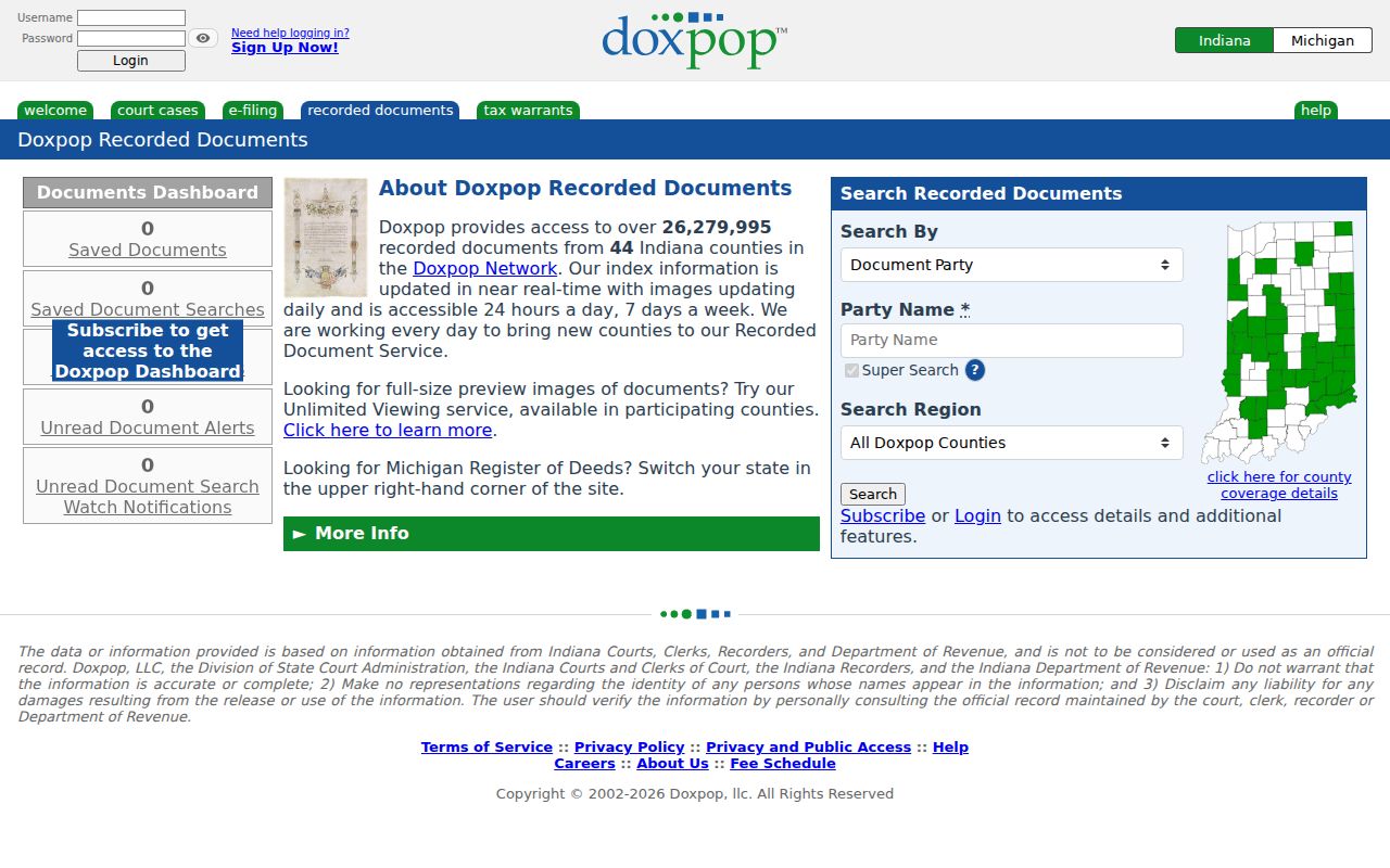
A legal-description match keeps a same-name party from being tied to the wrong parcel.
Brownsburg Recorded Document Routes
The official recorded-documents page routes users to provider and Recorder services.
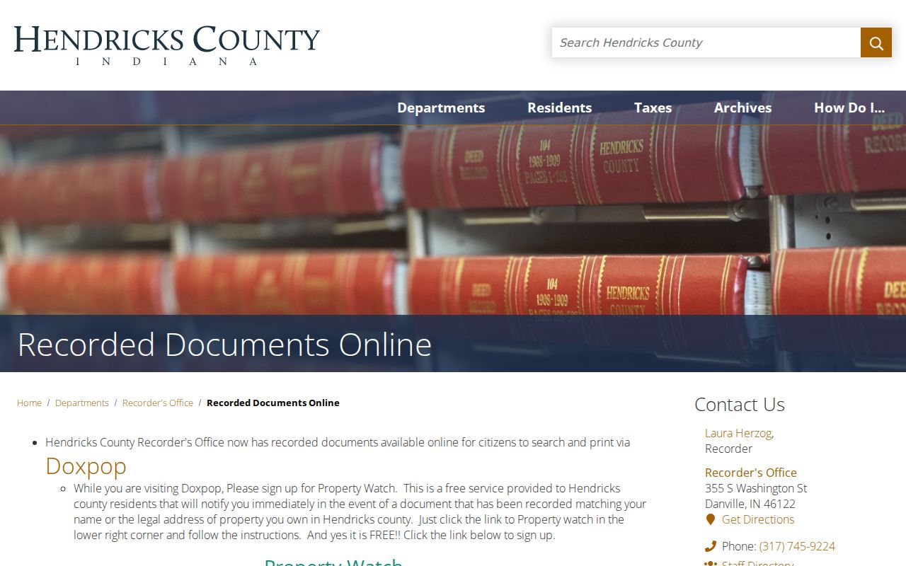
Use the county page when an image is absent, a certified copy is needed, or the online index ends too late for the question.
Archive menus add plats, transfer cards, recorder books, probate, and other scans. Many are browse-only. Call or visit the Recorder for an official instrument, consult State Library aids for film, and ask library staff for map support. A modern portal cannot cover an old road's full life.
Five Brownsburg Address Labels
The situs address is the parcel site. The mailing address is a tax-notice destination. A legal description identifies the land in a deed or plat. USPS supplies the postal label. Town GIS marks corporate limits and township. A trustee or estate may receive mail elsewhere while the mapped land remains local.
Older sources may say Brown Township, village, railroad point, or Hendricks County. Rail service began in 1879 and commuter service followed in 1910. No complete Brownsburg renumbering schedule was found. Bridge an old number through legal description, dated plat, atlas, newspaper, and library help.
Key distinction. A postal city, assessed owner, mapped parcel, and incorporated boundary answer four different questions.
Brownsburg Plats and Street Changes
An address may represent a subdivision lot, unplatted tract, or metes-and-bounds description, meaning land defined by measured directions and distances. GIS shows subdivision, lot, acres, and legal text. Recorder plats establish legal lots, roads, and easements.
For a permit, inspection, rezone, annexation, or code record absent online, contact Development Services or submit a Town request. Give the address, parcel, record type, and date range. The public-hearings map adds planning context, but a packet does not establish occupancy.
Older Brownsburg Street Evidence
No standalone Brownsburg street-directory run was found in the State Library list. The 1880 to 1881 Polk gazetteer names public and commercial figures but gives no street or household fields. Cite the actual volume and page behind any historical address claim.
The Brownsburg Library, Plainfield Indiana Room, State Library maps, archive, census, obituary, and probate sources form the fallback chain. A house history combines deeds, maps, directories, news, photos, and staff help. The full shelf belongs on the Brownsburg city directory page; use each item here only to tie a date to an address.
Note: A federal census describes a household on one enumeration date and should never be read as current occupancy.
Limits of Brownsburg Street Records
Property data generally omits renters, guests, children, and other household members. Utility customers and private association rosters are not assumed public. Motor-vehicle personal information is protected. IndianaVoters requires a name, birth date, and county, and cannot browse a street. Protected addresses may be withheld or substituted.
Use the Brownsburg street directory for family history, property research, civic questions, or lawful reconnection. Confirm ownership through the Assessor and Recorder. Describe occupancy only as dated evidence, never a present fact.
Lawful use. Never use address records to stalk, harass, intimidate, or harm a person, and never publish protected identifiers or addresses.
When a portal fails, keep the search tied to the street and date. Call the Hendricks County Assessor for a parcel record, ask the Recorder about an indexed instrument or older deed book, and use the county archive for transfer cards and plats. Brownsburg Public Library and the Plainfield Library Indiana Room can help with printed address sources. A narrow APRA request may reach an existing town record, but it cannot require the town to build a new street directory.